Antioquia Department
The Antioquia department has Medellín as its capital. The 125 municipalities of Antioquia are distributed in 9 subregions in 2 Natural Regions.
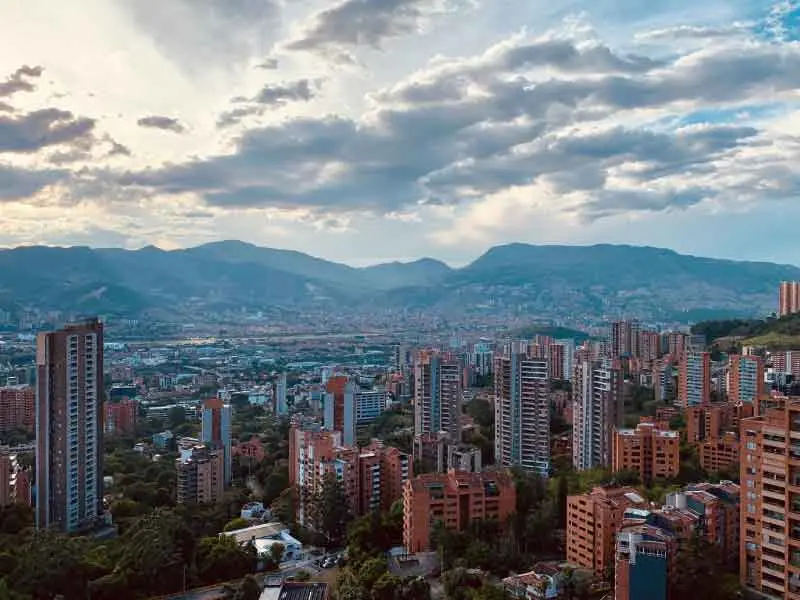
The department of Antioquia has the second most populous city in the country, the city of Medellín, its capital. It is located in the northwest of the country, in the regions Andina and Caribe. It is one of the largest departments in the country with 63,600 km² and is considered the most populous department in all of Colombia.
It borders the north with the Atlantic Ocean, as well as the departments of Córdoba and Bolívar, to the east with Santander and Boyacá, to the south with Caldas and Risaralda, and to the west with Chocó.
Its astronomical position is between 5°25′ and 8°55′ of north latitude and 73°53′ and 77°07′ of western longitude.
With a strong and thriving economy, it manages to generate 13.9% of the GDP in Colombia, surpassed only by Bogotá.
It was created on August 5, 1886 under the terms of the 1886 Constitution.
IMPORTANT DATA
CAPITAL
MEDELLÍN
POPULATION
6,690,980
GENTILICIO
ANTIOQUEÑO
SURFACE AREA
63,612 km²
GOVERNOR
Andrés Julián Rendón Cardona
OFFICIAL WEB
Map of the Antioquia Department
The following municipalities of Antioquia are located on the map:
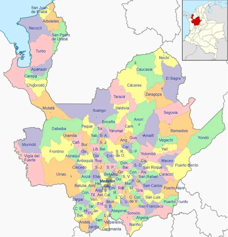
SUBREGIONS OF ANTIOQUIA
The Antioquia department has a total of 125 municipalities, distributed in 9 subregions, which are:
- Bajo Cauca
- Magdalena Medio
- Nordeste
- Norte
- Occidente
- Oriente
- Suroeste
- Urabá
- Valle de Aburrá
MUNICIPALITIES OF ANTIOQUIA
The following is the list of 125 municipalities of Antioquia including the subregion to which they belong:
| Municipality Name | Subregion |
| Cáceres | Bajo Cauca |
| Caucasia | Bajo Cauca |
| El Bagre | Bajo Cauca |
| Nechí | Bajo Cauca |
| Tarazá | Bajo Cauca |
| Zaragoza | Bajo Cauca |
| Caracolí | Magdalena Medio |
| Maceo | Magdalena Medio |
| Puerto Berrío | Magdalena Medio |
| Puerto Nare | Magdalena Medio |
| Puerto Triunfo | Magdalena Medio |
| Yondó | Magdalena Medio |
| Amalfi | Nordeste |
| Anorí | Nordeste |
| Cisneros | Nordeste |
| Remedios | Nordeste |
| San Roque | Nordeste |
| Santo Domingo | Nordeste |
| Segovia | Nordeste |
| Vegachí | Nordeste |
| Yalí | Nordeste |
| Yolombó | Nordeste |
| Angostura | Norte |
| Belmira | Norte |
| Briceño | Norte |
| Campamento | Norte |
| Carolina del Príncipe | Norte |
| Donmatías | Norte |
| Entrerríos | Norte |
| Gómez Plata | Norte |
| Guadalupe | Norte |
| Ituango | Norte |
| San Andrés de Cuerquia | Norte |
| San José de la Montaña | Norte |
| San Pedro de los Milagros | Norte |
| Santa Rosa de Osos | Norte |
| Toledo | Norte |
| Valdivia | Norte |
| Yarumal | Norte |
| Abriaquí | Occidente |
| Antioquia | Occidente |
| Anzá | Occidente |
| Armenia | Occidente |
| Buriticá | Occidente |
| Caicedo | Occidente |
| Cañasgordas | Occidente |
| Dabeiba | Occidente |
| Ebéjico | Occidente |
| Frontino | Occidente |
| Giraldo | Occidente |
| Heliconia | Occidente |
| Liborina | Occidente |
| Olaya | Occidente |
| Peque | Occidente |
| Sabanalarga | Occidente |
| San Jerónimo | Occidente |
| Sopetrán | Occidente |
| Uramita | Occidente |
| Abejorral | Oriente |
| Alejandría | Oriente |
| Argelia | Oriente |
| El Carmen de Viboral | Oriente |
| Cocorná | Oriente |
| Concepción | Oriente |
| El Peñol | Oriente |
| El Retiro | Oriente |
| El Santuario | Oriente |
| Granada | Oriente |
| Guarne | Oriente |
| Guatapé | Oriente |
| La Ceja | Oriente |
| La Unión | Oriente |
| Marinilla | Oriente |
| Nariño | Oriente |
| Rionegro | Oriente |
| San Carlos | Oriente |
| San Francisco | Oriente |
| San Luis | Oriente |
| San Rafael | Oriente |
| San Vicente | Oriente |
| Sonsón | Oriente |
| Amagá | Suroeste |
| Andes | Suroeste |
| Angelópolis | Suroeste |
| Betania | Suroeste |
| Betulia | Suroeste |
| Caramanta | Suroeste |
| Ciudad Bolívar | Suroeste |
| Concordia | Suroeste |
| Fredonia | Suroeste |
| Hispania | Suroeste |
| Jardín | Suroeste |
| Jericó |
| Name | Population |
| Medellín | 2457680 |
| Bello | 464560 |
| Itagüí | 270920 |
| Envigado | 227599 |
| Apartadó | 183716 |
| Turbo | 163525 |
| Rionegro | 122231 |
| Caucasia | 114902 |
| Caldas | 78762 |
| Chigorodó | 78148 |
| Copacabana | 71033 |
| Necoclí | 63991 |
| La Estrella | 63332 |
| Carepa | 57220 |
| Girardota | 55477 |
| Marinilla | 54186 |
| La Ceja | 53361 |
| Sabaneta | 52559 |
| Barbosa | 50832 |
| El Bagre | 49913 |
| Guarne | 48659 |
| Puerto Berrío | 47717 |
| Yarumal | 47436 |
| El Carmen de Viboral | 47340 |
| Andes | 46221 |
| Urrao | 45266 |
| Tarazá | 43856 |
| Arboletes | 41209 |
| Segovia | 40688 |
| Cáceres | 38850 |
| Santa Rosa de Osos | 36103 |
| Sonsón | 35056 |
| San Pedro de Urabá | 31539 |
| Zaragoza | 31129 |
| Remedios | 29898 |
| Amagá | 29770 |
| Nechí | 27238 |
| El Santuario | 27176 |
| San Pedro de los Milagros | 27059 |
| Ciudad Bolívar | 26957 |
| San Juan de Urabá | 25652 |
| Antioquia | 24724 |
| Yolombó | 24384 |
| Dabeiba | 23280 |
| Valdivia | 22754 |
| Donmatías | 22726 |
| Amalfi | 22253 |
| Santa Bárbara | 21917 |
| Fredonia | 21426 |
| Mutatá | 21077 |
| Ituango | 20628 |
| Concordia | 20565 |
| Puerto Triunfo | 20483 |
| El Retiro | 19310 |
| La Unión | 19229 |
| Abejorral | 19195 |
| Yondó | 18992 |
| Puerto Nare | 18846 |
| Betulia | 17606 |
| Salgar | 17539 |
| Nariño | 17486 |
| Anorí | 17304 |
| San Vicente | 16967 |
| Cañasgordas | 16751 |
| San Roque | 16663 |
| Frontino | 16311 |
| San Carlos | 16086 |
| El Peñol | 15848 |
| Cocorná | 14964 |
| Sopetrán | 14821 |
| Támesis | 14559 |
| Titiribí | 14494 |
| Jardín | 13673 |
| Venecia | 13231 |
| Gómez Plata | 12964 |
| San Rafael | 12920 |
| San Jerónimo | 12724 |
| Ebéjico | 12510 |
| Jericó | 12016 |
| Angostura | 11240 |
| Peque | 11064 |
| San Luis | 10938 |
| Santo Domingo | 10292 |
| Entrerríos | 10102 |
| Granada | 9866 |
| Liborina | 9546 |
| Vegachí | 9273 |
| Betania | 9188 |
| Angelópolis | 9082 |
| Campamento | 9035 |
| Cisneros | 8998 |
| Briceño | 8692 |
| Argelia | 8578 |
| Yalí | 8400 |
| Caicedo | 8275 |
| Uramita | 8230 |
| Sabanalarga | 8191 |
|
The expeditionary Gaspar de Rodas was the conqueror of the lands of the cacique Niquío who was defeated by him in 1545, during the colony the mestizaje took place in the area although this is one of the purest races in the country; before independence and much after this the start and form of the so-called paisa colonization towards Old Caldas took place.
In 1856 the Sovereign State of Antioquia was created and in 1886 it returned to being a department. RELIEVE
This area of the country is mostly a mountainous territory with 241 kilometers of coastline on the Caribbean Sea; its main forms of relief are:
HIDROGRAFÍA
It is a department that counts at the hydrographic level with the potential of the rivers Magdalena, Cauca and Atrato. Other rivers that run through the territory of the department are the Nare, La Miel, Nechi, San Juan and Sinú. CLIMA
The department of Antioquia due to its mountainous topography presents an altitude climate or according to the thermal floors. ECONOMY
In the flat zone of the department, pastures and oil are found and exploited; in the broken zones, gold, silver, quartz, pyrite, lead, chromites, and coal mines are exploited. There are lands suitable for traditional agriculture with the cultivation of potatoes, tobacco, beans, sugarcane, etc.; for technified agriculture with fique and for export agriculture with coffee, bananas, and flowers; also important is the industrial activity with the production of textiles, clothing, graphic arts, household appliances, food products, etc. Similarly, livestock is of lesser importance. NATURAL RESERVES
In the department, there are four natural reserves:
ANthemLyrics: Epifanio Mejía Music: Gonzalo Vidal CHORUS
Oh liberty that perfumes
I
II
III
IV
V
VI
VII
VIII
IX
X
XI
XII
XIII
XIV
XV
XVI
XVII
XVIII
XIX
XX
XXI
XXII
XXIII See The Andean Region of Colombia |
You may also be interested in