Andean Region of Colombia
Andean region: list of 13 departments, capitals, climate and profiles. Overlaps where they apply (Valle, Cauca and Nariño also Pacific; Urabá in Antioquia).
Updated 23 Sep 2026 · Source: Wikipedia / geography
The Andean region of Colombia is one of the country’s six natural regions. It groups 13 departments plus Bogotá D.C.: Antioquia, Boyacá, Caldas, Cauca, Cundinamarca, Huila, Nariño, Norte de Santander, Quindío, Risaralda, Santander, Tolima and Valle del Cauca.
It runs through the center of the country along the three Andean ranges. It is Colombia’s most populated and urbanized zone. It includes Bogotá, Medellín, Cali, Bucaramanga and Manizales. In broad terms it meets the Caribbean region to the north, the Orinoquía and the Amazon to the east and southeast, and the Pacific fringe to the west.
See the natural regions hub.
Departments and capitals
| Department | Capital | Profile |
|---|---|---|
| Antioquia | Medellín | /en/departamento/antioquia/ |
| Boyacá | Tunja | /en/departamento/boyaca/ |
| Caldas | Manizales | /en/departamento/caldas/ |
| Cauca | Popayán | /en/departamento/cauca/ |
| Cundinamarca | Bogotá D.C. (listed as capital; see note) | /en/departamento/cundinamarca/ |
| Huila | Neiva | /en/departamento/huila/ |
| Nariño | Pasto | /en/departamento/narino/ |
| Norte de Santander | Cúcuta | /en/departamento/norte-de-santander/ |
| Quindío | Armenia | /en/departamento/quindio/ |
| Risaralda | Pereira | /en/departamento/risaralda/ |
| Santander | Bucaramanga | /en/departamento/santander/ |
| Tolima | Ibagué | /en/departamento/tolima/ |
| Valle del Cauca | Cali | /en/departamento/valle-del-cauca/ |
Bogotá D.C.: Capital District associated with the Andean region. It is not a department and it is not a municipality of Cundinamarca.
Also touches
| Department | Note |
|---|---|
| Valle del Cauca, Cauca, Nariño | Andean interior here; the coast also belongs to the Pacific region (Buenaventura, Guapi, Tumaco). |
| Antioquia | Urabá touches the Caribbean region; Antioquia stays Andean as its main listing. |
Caquetá, Cesar, Chocó, Putumayo and Córdoba are not part of this Andean list.
Location and relief
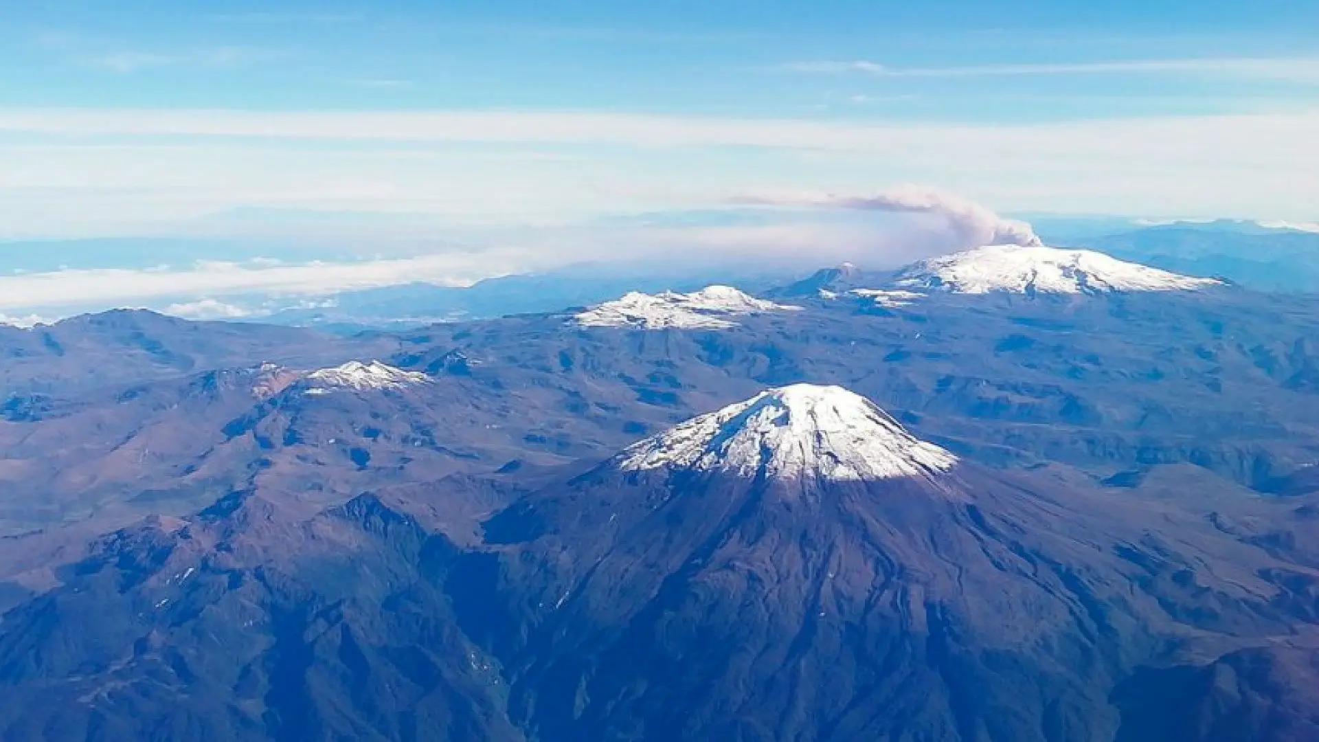
The region takes its name from the Andes. In Colombia the Andes split into the Western, Central and Eastern ranges, with knots and massifs (including the Colombian Massif and the Nudo de los Pastos).
Valleys (Magdalena, Cauca) and highlands (Cundiboyacense, Nariño) open between the ranges. There are páramos, snow peaks and foothills. Relief explains the thermal climates.
Climate
Climate changes with altitude: warm in low valleys, temperate on middle slopes, cold and páramo higher up. This page does not publish °C averages without a cited source.
Hydrography
- Magdalena River
- Cauca River
- Bogotá River
- Sogamoso / Chicamocha River
- Patía River (upper course)
- Catatumbo River
- Nechí / Porce River
Many headwaters rise in páramos and feed water systems and hydropower.
Economy
This is the region with the greatest urban and industrial weight. Highlights: industry and services in large cities; coffee (Coffee Axis and other zones); flowers and potatoes on the highlands; sugarcane and agribusiness in the Cauca valley; trade, education and urban and nature tourism.
Culture, food and festivals
School texts often name these cultural areas: Paisa (Antioquia and the Coffee Axis), Cundiboyacense, Santander, Valle del Cauca, Opita (Tolima–Huila) and Pastuso (Nariño).
Food (examples): bandeja paisa, ajiaco, lechona, tamal, arepa, sancocho, mazamorra.
Festivals (selection): Silleteros Parade (Medellín/Antioquia), International Coffee Pageant (Manizales), International Festival of Culture (Tunja), San Pedro and Sanjuanero (Huila/Tolima), Cali Fair, Blacks and Whites Carnival (Pasto; the department also has a Pacific coast).
Natural parks (selection)
- Los Nevados National Park
- Chingaza National Park
- Sumapaz National Park
- El Cocuy National Park
- Puracé National Park
- Farallones de Cali National Park
- Nevado del Huila National Park
- Iguaque Flora and Fauna Sanctuary
Natural subregions (reference)
- Cundiboyacense highlands
- Cauca and Magdalena river valleys
- Coffee Axis (Caldas, Quindío, Risaralda and nearby areas)
- Colombian Massif and Nudo de los Pastos
- Antioquia mountains and Aburrá valley
- Chicamocha canyon and Santander mountains
They help place landscapes. They do not change the count of 13 departments.
Frequently asked questions
How many departments does the Andean region have?
13, plus Bogotá D.C. as an associated district. See the table above.
Is the Andean region the largest?
We do not claim that here. It is the most populated. Area in km² only with a verified figure.
Are Cauca, Valle and Nariño only Andean?
Not entirely. They have an Andean interior (Popayán, Cali, Pasto) and also a coastal strip in the Pacific region.
Why are Caquetá, Cesar, Chocó and Putumayo missing?
Because they belong to the Amazon, Caribbean or Pacific lists. They are not part of this Andean core.
Other regions
Sources
Copy review: 23 Sep 2026 (America/Bogota). Version v3-mau-wikipedia.