Nariño Department
Nariño is located in the Andean and Pacific regions. Its capital is San Juan de Pasto. It is the best-known border to the south of the country with Ecuador.
The department of Nariño is located in the Andean and Pacific regions. Its capital is San Juan de Pasto.
It borders the north with Cauca, the east with Putumayo, the south with Ecuador, and the west with the Pacific Ocean.
The department receives its name from the independence hero and president Antonio Nariño.
This department has a diverse geography and varied climate, with a warm climate in the Pacific plain and a cold climate in the mountainous area, where most of the population is located. The department is mostly agricultural and livestock-based.
IMPORTANT DATA
CAPITAL
SAN JUAN DE PASTO
POPULATION
1.713.586 (2025)
GENTILICIO
NARIÑENSE
SURFACE AREA
33268 km²
GOVERNOR
Luis Alfonso Escobar Jaramillo
OFFICIAL WEBSITE
Map of the Department of Nariño
The following municipalities of Nariño are located on the department’s map:
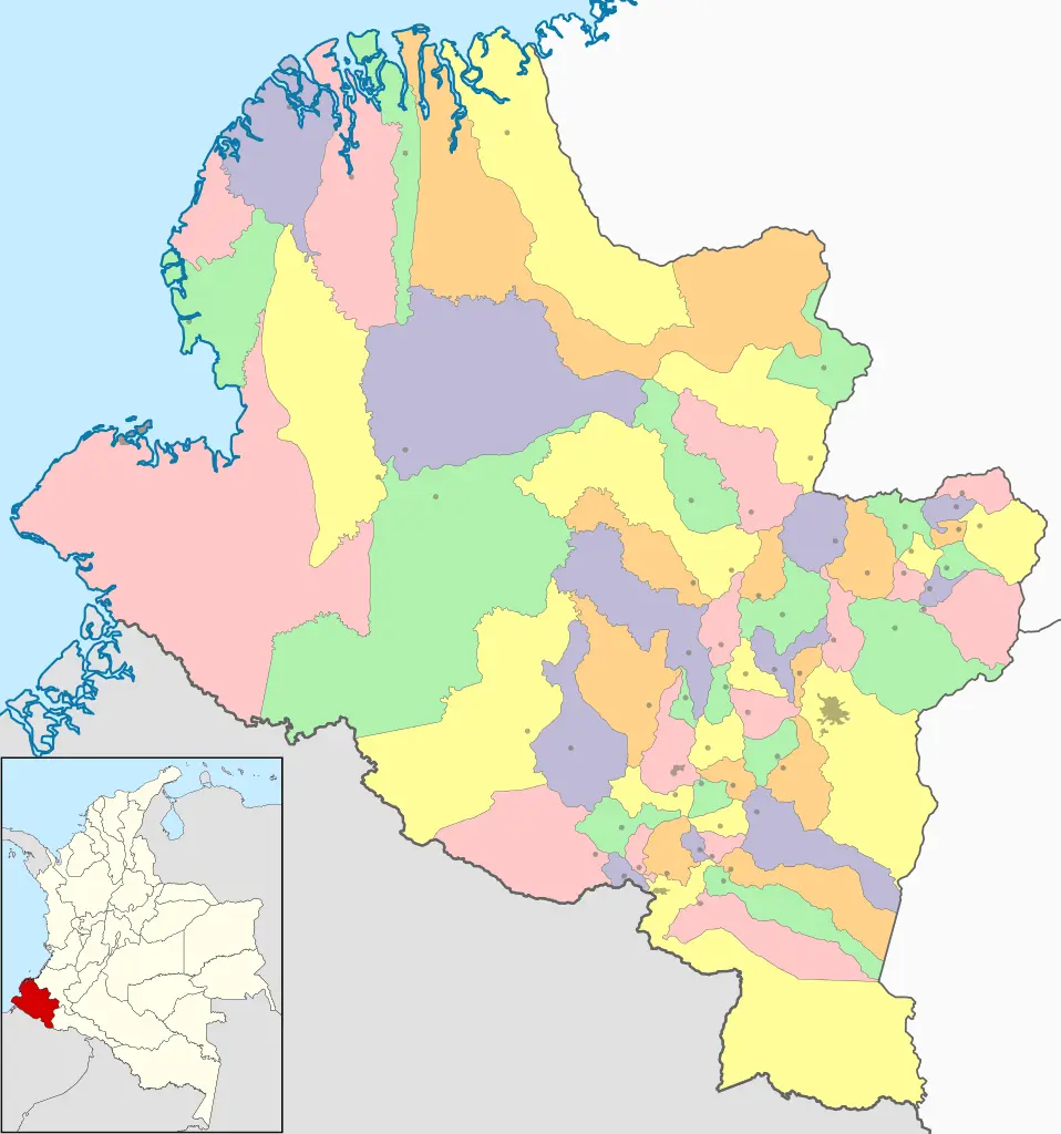
Subregions of Nariño
The department is divided into 5 subregions, which are listed below:
- Pasto
- Tumaco – Barbacoas
- Obando
- Juanambú
- Túquerres
Municipalities of Nariño
The department of Nariño is divided into 64 municipalities, which are grouped into the 5 subregions listed above.
The following is the complete list of municipalities of the department of Nariño:
Pasto
- Pasto (capital of Nariño)
- Buesaco
- Chachagüí
- Consacá
- El Peñol
- El Tambo
- La Florida
- Nariño
- Sandoná
- Tangua
- Yacuanquer
Tumaco – Barbacoas
- Barbacoas
- El Charco
- Francisco Pizarro
- La Tola
- Magüí
- Mosquera
- Olaya Herrera
- Roberto Payán
- Santa Bárbara
- Tumaco
Obando
- Aldana
- Contadero
- Córdoba
- Cuaspud
- Cumbal
- Funes
- Guachucal
- Gualmatán
- Iles
- Ipiales
- Potosí
- Puerres
- Pupiales
Juanambú
- Albán
- Arboleda
- Belén
- Colón
- El Rosario
- El Tablón de Gómez
- La Cruz
- La Unión
- Leiva
- Policarpa
- San Bernardo
- San Lorenzo
- San Pablo
- San Pedro de Cartago
- Taminango
Túquerres
- Ancuyá
- Cumbitara
- Guaitarilla
- Imués
- La Llanada
- Linares
- Los Andes
- Mallama
- Ospina
- Providencia
- Ricaurte
- Samaniego
- Santacruz
- Sapuyes
- Túquerres
HISTORY
This area was inhabited by indigenous peoples such as the quillancigas, pastos, iscuandés, tumas, and pachilimbíes. The first conquistador to set foot in this territory was Pascual de Andagoya in 1522, who led an expedition at that time. In 1541, he divided this area into 14 tenancies, marking the beginning of the conquest and population process.
In 1904, it was created as a department with the name of Nariño
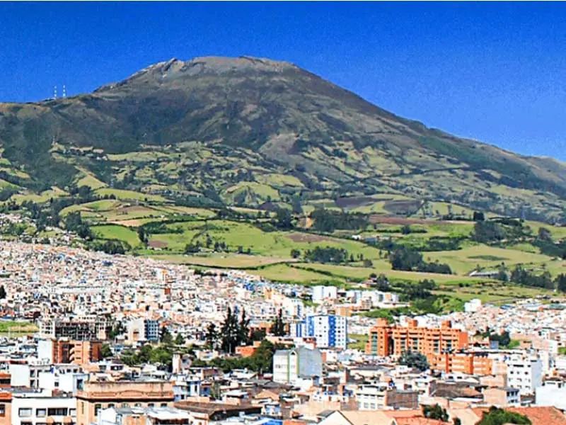
RELIEVE
Nariño is divided into three regions. The left branch constitutes the Eastern Cordillera, which culminates in the volcanoes of Chiles, Cumbal and Azufral, the right branch will form the Central and Western Cordilleras, culminating in the volcanoes Galeras and Doña Juana; finally, the Coastal Plain or Pacific, a flat area that occupies almost half of the territory, between the Western Cordillera and the Pacific Ocean coast.
CLIMATE
In the Pacific Plain region, temperatures are high, abundant rain in the Andean region, while in the remaining territory the temperature is low. For this reason, the average temperature is 14oC.
ECONOMY
The region is determined by the fluctuation of the Ecuadorian currency since the exchange between the two countries is quite active.
Agricultural production is the base of the economy, also complemented by livestock, mining, and manufacturing industry.
This area produces potatoes, plantains, African palm, fique, sugarcane, cereals, corn, coffee, broad beans, carrots, and peas.
Mining is an important sector in the Nariño economy with the exploitation of gold and silver; there are deposits of copper, lead, and zinc.
HYDROGRAPHY
The most notable rivers are the Patía with its tributary the Telembí, the Putumayo, the Caquetá, the Mira, and the Juanambú. Lakes such as Azufral, Verde, and Laguna Concha. Two drainage basins are distinguished, the eastern and western.
NATURAL RESERVES
It has beautiful places like Ipiales called “The City of the Green Clouds”. The Gaitara Canyon, where, the imposing and majestic sanctuary of Our Lady of the Lajas of Gothic style rises.
HIMNO
Lyrics:
Alberto Quijano Guerrero
Music: Luis Ignacio Martínez
CHORUS
From the sea to Galeras
from the mountain to the limit
there are lullabies of the flag
and fanfares of the trumpet.
In the triumphant framework of history
a cry resounds: "Ascend to the summit!"
The trumpets announce glory
and Nariño responds to conquer!
I
Hail, oh land, your fertile fields
eternalize divine brushes;
your old laurels are already sprouting
along with the white rose of the cross.
II
Your current of love and heroism
rests in calm pools of peace,
and in the vital furrow of your race
work is the seed of light.
III
Don Julián symbolizes your shield
of men without fear or shadow:
and to the centuries and peoples it astonishes
your virtue, your knowledge, your valor…
IV
Your sublime torch illuminates you
which in your right hand is aroma and fire:
honor and prestige of the brave farmer
who caresses the rifle and the flower.
V
In your blessed and fertile entrails
the past revives in the present.
You are a martyr, an artist, a soldier,
sun in Tarquí, star in Guepí…
VI
To the rumor of the perpetual miracle
that embellishes your sacred borders
in the vegetal battle of the eras
victory will be yours.
You may also be interested in