Huila Department
Huila is a department of Colombia whose capital is Neiva and is located in the southwestern part of the country, in the Andean region.
The department of Huila is a department located in the southwest of the country, in the Andean region.
Its capital is Neiva and it borders to the north with Tolima and Cundinamarca, to the east with Meta, to the south with Caquetá and to the west with Cauca.
The department is located in the southwestern part of the country, between the Central and Eastern mountain ranges and has as extreme points the Riachón River at 3° 55′ 12″ north latitude and the Punto Hill at 1°30’04″ north latitude and its longitude west of Greenwich, it is between 74°25’24″ and 76°35’16″.
It was created in 1905 and the origin of its name is not yet very clear, it is attributed to some indigenous languages where "Huila" can mean "Orange" or "Luminous Mountain", this in reference to the Nevado del Huila.
IMPORTANT DATA
CAPITAL
NEIVA
POPULATION
1’197.049
GENTILICIO
HUILENSE
SURFACE AREA
19.890 km²
GOVERNOR
Rodrigo Villalba Mosquera
OFFICIAL WEBSITE
Map of the Department of Huila
Follow the municipalities of Huila located on the map:
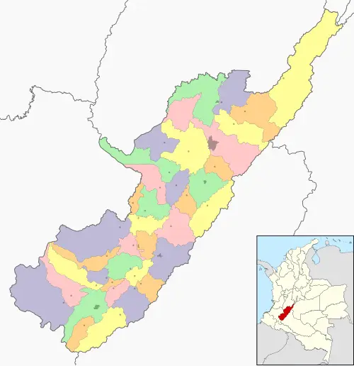
Map by: Wikimedia Commons / CC BY-SA
SUBREGIONES DEL DEPARTAMENTO DEL HUILA
The department of Huila is divided into 4 subregions which are:
- Subcenter
- Subnorth
- Subwest
- Subsouth
MUNICIPIOS DEL DEPARTAMENTO DEL HUILA
The department of Huila has 37 municipalities listed below in their respective subregions:
Subcenter
- Altamira
- Agrado
- Garzón
- Gigante
- Pital
- Guadalupe
- Tarqui
- Suaza
Subnorth
- Aipe
- Algeciras
- Baraya
- Campoalegre
- Colombia
- Hobo
- Íquira
- Neiva
- Palermo
- Rivera
- Santa María
- Tello
- Teruel
- Villavieja
- Yaguará
Subwest
- La Argentina
- La Plata
- Nátaga
- Paicol
- Tesalia
Subsouth
- Acevedo
- Elías
- Isnos
- Oporapa
- Palestina
- Pitalito
- Saladoblanco
- San Agustín
- Timaná
HISTORY
The area was inhabited by indigenous people of the San Agustín culture, famous for the use of stone in monumental statues, tombs and sculptural decorations, little is known about their origins and subsequent decline.
In the conquest era the predominant indigenous group was the Caribe family, warriors and cannibals, who opposed resistance to the Europeans.
In 1539, Juan de Cabrera founded Neiva, but the city was destroyed on several occasions, until in 1612, Diego de Ospina y Medinilla rebuilt it in its current location; throughout its history, it formed part of Popayán 1541, Cundinamarca 1819. In 1861 it passed to form part of the federal state of Tolima; finally, Law 46 of 1905 created the department of Huila.
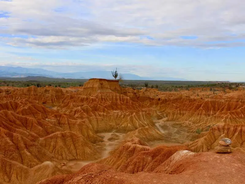
RELIEVE
Limited by the Central and Eastern cordilleras that branch off in the territory. Huila is occupied by the Magdalena River valley in most of its area, the Central Cordillera, to the west begins with the Páramo de las Papas and continues with the Sierra Nevada de los Coconucos.
The Puracé volcano reaches the Guacanás pass from where the Paicol serranía emerges, the volcano forms a natural park of 83,000 hectares that brings together seven volcanoes and snow-capped mountains.
In the Central Cordillera, the Nevado del Huila is located, which forms the natural park, it is the highest elevation of the Colombian Andes with 5,750 msnm, the Coconucos and Caruca hills and towards the northeast of the Serranía de Iguaque, the Alto de los Cauchos and the Santa Bárbara Cordillera.
The Eastern Cordillera is narrow and low, towards the south it forms part of the Colombian Massif, in the northeast it forms the Páramo de las Cruces and the Cerro del Purgatorio, Damas del Alto de la Cajuela, the Puchincha Cordillera and the hills of La Osera and El Fraile.
HIDROGRAFÍA
In it, the Magdalena, Cauca, Patía, and Caquetá rivers are born; in the western part, the rivers of La Plata, Baché, Aipe, Yaguará, Paez, Mazamorras, and Bordones are distinguished.
In the eastern part, the Cabrera, Suiza, Neiva, Timaná, Gurapos, Naranjos, Guachicos, Frio, Ceibas, Fortalecillas, and Viejanueva rivers flow.
The most known lagoons are those of the Magdalena that originate the river and those of the Llano del Juncal in the Serranías de Neiva that is also known as Laguna de la Manga.
CLIMA
In the Huila department, the temperature of its capital Neiva is 28°C, the thermal floors, the variety of climate and rainfall are determining factors for the economy of Huila.
In the center of the valley, medium-high zone, the temperature is 24°C and the average precipitation is 1,250 mm per year; towards the south and west of the department it is 20°C, in the middle it reaches 10°C and in the Nevado del Huila and the Sierra Nevada de Coconucos the temperature is below 0°C.
The periods of rainfall are very well defined; the thermal floors are divided into warm, which occupies 5,528 km², cold 5,290 km² and Paramo 1,359 km².
ECONOMÍA
Agricultural production is based on the cultivation of rice, sorghum, potato, cotton, corn, tobacco, soy, sesame, and peanut as transitory crops and the permanent ones are banana, cassava, sugarcane, and cacao.
Regarding coffee, it is the ninth producer in the country, being thus municipalities of greater production Garzón, Pitalito, and Gigante.
RESERVAS NATURALES
The Huila department offers a multiplicity of natural landscapes and sites impregnated with history and resources.
The volcanoes of Puracé and del Huila are the habitat of a large number of birds, approximately 200 species, and mammals such as the Tapir and the Conejo Venado.
HIMNO
Lyrics:
Luis Alberto Osorio
CHORUS
With the tenderness
of my land
that saw me born,
my soul sings
with the entire joy
of a dawn.
I
Land of the soul
that I love so much
with my heart,
it is the soul of Huila
land of promise.
II
In my land for good
a river crosses without equal
that gives life
to the farmer,
to his maize field,
to his banana plantation.
III
It is Huila my feeling,
I give my life to return,
to my beloved land
to sing to it with pleasure.
You may also be interested in