Magdalena Department
Magdalena is a department of Colombia. Its capital is Santa Marta and it is located in the Caribbean region.
The department of Magdalena is a department of Colombia. Its capital is Santa Marta and it is located in the Caribbean region.
It borders the north with the Atlantic Ocean and La Guajira, to the east with Cesar, to the south and west with Bolívar and to the northwest with Atlántico.
It is located north of the Caribbean region, its northern latitude is located between the Neguanje point at 11°36’58” and the El Jobo island at 8°56’26”. The easternmost point is in the Ichacuí ridge at 73°32’50” and the westernmost point is on a small island on the Magdalena River at 74°56’45” west of Greenwich.
The Magdalena department was one of the nine original states that formed the Estados Unidos de Colombia.
Its name comes from the Magdalena River, which bathes it on its western side.
In the north of the department is the municipality of Aracataca, known for being the place where the Colombian Nobel laureate in literature, Gabriel García Márquez, was born in 1927.
Additionally, in Santa Marta, the capital of the department, the liberator Simón Bolívar died in 1830.
IMPORTANT DATA
CAPITAL
SANTA MARTA
POPULATION
1’298.562
GENTILICIO
MAGDALENENSE
AREA
23.188 km²
GOVERNOR
María Margarita Guerra Zúñiga
OFFICIAL WEBSITE
Map of the Magdalena Department
Below are the municipalities of Magdalena located on the map:
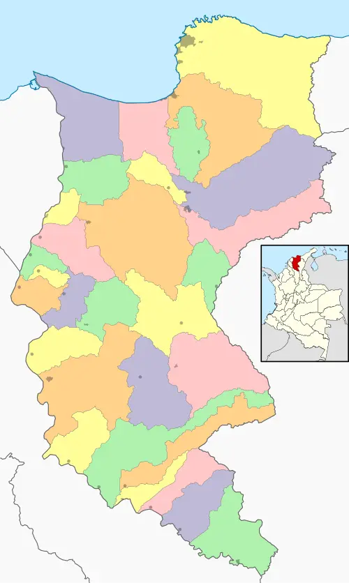
Map by: Wikimedia Commons / CC BY-SA
SUBREGIONS OF THE MAGDALENA DEPARTMENT
The Magdalena department has five subregions named below:
- Center
- South
- North
- River
- Santa Marta
MUNICIPALITIES OF THE MAGDALENA DEPARTMENT
The Magdalena department has 30 municipalities listed below in their respective subregions:
Center
- Ariguaní
- Chibolo
- Nueva Granada
- Plato
- Sabanas de San Angel
- Tenerife
South
- El Banco
- Guamal
- Pijiño del Carmen
- San Sebastián de Buenavista
- San Zenón
- Santa Ana
- Santa Bárbara de Pinto
North
- Algarrobo
- Aracataca
- Ciénaga
- El Retén
- Fundación
- Pueblo Viejo
- Zona Bananera
River
- Cerro Antonio
- Concordia
- El Piñon
- Pedraza
- Pivijay
- Remolino
- Salamina
- Sitionuevo
- Zapayán
Santa Marta
- Santa Marta
HISTORY
This area was inhabited by Carib and Arawak Indians. The indigenous people were organized in the provinces of Betoma, Tayrona, Carbón, Caribes, Orejones, Tayronaca, Macongana, Arhuaco, Chimila, Sandagua, and Pocabuy.
Alonso de Ojeda explored the Bay of Santa Marta in 1498. Later in 1501, Rodrigo de Bastidas traveled along the coast but only until 1525 was it possible to hoist the crown's flag and take possession of the province of Santa Marta on July 25.
Finally, the indigenous populations were reduced to encomiendas, through which the servitude was limited and their economic development was limited. It became an important port for our homeland.
RELIEF
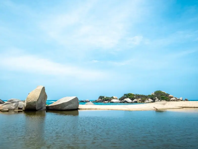
Several topographic contrasts are found. The Sierra Nevada de Santa Marta can be identified as an accident, which is the highest mountain on the coast in the world. Other physiographic regions of the department are the beaches of Dibulla. In addition to the Sierra Nevada de Santa Marta, we also find the Tayrona Park, Salamanca Island, and the Great Swamp.
HYDROGRAPHY
In the Magdalena there is a large number of swamps, including Zapatosa, Chilloa, Pijiño, Del sapo, Malibú, Zárate, Morro, Zapayá, Cerro de San Antonio, Buenavista, Aguja, Tamacal, Conchal, Pajaral, Atascosa, Chinú, and the most important, the Great Swamp of Santa Marta.
CLIMATE
In most of the department, the climate is dry with a mean temperature of 29°C, which is cooled by the northwest trade winds. In the areas of the Sierra Nevada, all climates and temperatures are found, including perpetual snow and the highest degree of rainfall.
The dry season of summer extends from November to April, the rest of the months are considered rainy; most of the thermal floors are located in the warm and medium climates, the first occupies 19,800 km2 and the second 1,757 km2. The cold floors and páramos occupy between 790 km2 and 841 km2.
ECONOMY
The soils are very exploitable and present oil fields, agriculture has great importance for the economy of Magdalena in this area, maize, yuca, rice, banana, African palm, sorghum, coconut, cotton, and black tobacco are also cultivated.
Another product is livestock with a 36% in Pivijay, Plato, and El Banco. Also, it is noted as a livestock population in Aracataca, Ariguaní, and Santa Ana.
Another product is coffee, which is grown in the foothills of the Sierra Nevada de Santa Marta.
NATURAL RESERVES
Every year the Samarios show and share their joy in the famous Fiesta del Mar.
It is a zone of great tourist influence due to the fact that there are places of special attraction such as the Ethnological and Anthropological Museum, in addition to the tours around the city, which show the indigenous traditions.
It has sites such as the Sierra Nevada, Taganga, and the Rodadero.
HYMN
lyrics: Francisco Covilla Noguera
CORO
Al cantarte Magdalena mio
nuestras almas se llenan de paz
y del pecho arrogante y henchido
una voz nos escapa triunfal
I
Magdalena, tierra prometida
es tu nombre camino fluvial
Don Rodrigo Galván de Bastidas
desde Iberia te vino a encontrar.
II
Ni el tayrona aguerrido y valiente
con su sangre lo pudo evitar
y orgulloso se fue hasta tu frente
que es la sierra más alta del mar.
III
Desde el mar al cesar tu ribera
fue testigo de cruentas acciones
pocabuyes, chimilas, son fieras
con sus flechas y sus corazones.
IV
Desafiante un velero negrero
al bantu trajo cual mercancía
se mezclaron las razas primero
y hoy conviven en plena armonía.
V
Tus mujeres en gestas gloriosas
combatieron al fuerte español
y Dios quiso que en tu tierra hermosa
expirara el libertador.
VI
Los cultivos cambiaron la historia
del Macondo florido y feraz.
Yo quisiera siempre en mi memoria
el Caribe y el río soñar.
You may also be interested in