La Guajira Department
The Guajira is a department of Colombia located in the Caribbean Region and its capital is Riohacha. It has 5 natural parks, desert, indigenous towns and more.
The department of La Guajira (in wayuunaiki: Wajiira) is a department of Colombia located in the Caribbean Region and its capital is Riohacha.
It is located in the northeasternmost part of Colombia and borders the Atlantic Ocean to the north and east, Venezuela and Cesar to the south, and Magdalena to the west.
It is situated between 10°23′ and 12°28′ of latitude north and 71°06′ and 73°39′ of longitude west of Greenwich with an altitude of 3 msnm.
In its territory, the peninsula of La Guajira and parts of the Sierra Nevada, the Perijá Mountains and part of the Ranchería and Cesar rivers are found.
In the department of La Guajira, three natural parks of Colombia, five indigenous American towns and a large Arab community that has been fundamental to its economy are found.
It is composed of 15 municipalities. In La Guajira, the desert, dry and humid mountain forests predominate.
IMPORTANT DATA
CAPITAL
RIOHACHA
POPULATION
985.498
GENTILICIO
GUAJIRO
SURFACE AREA
20.848 km²
GOVERNOR
Jairo Alfonso Aguilar Deluque
OFFICIAL WEBSITE
Map of the Department of La Guajira
Below are the municipalities of La Guajira located on the map:
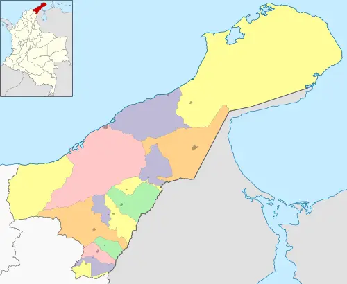
Map by: Wikimedia Commons / CC BY-SA
SUBREGIONS OF THE DEPARTMENT OF LA GUAJIRA
The department of La Guajira has two provinces or subregions:
- North
- South
Where a district, 44 corregimientos, 15 municipalities and inhabited places by indigenous Wayuu people called rancherías are found.
MUNICIPALITIES OF THE DEPARTMENT OF LA GUAJIRA
The department of La Guajira has 15 municipalities listed below:
South
- Barrancas
- Distracción
- El Molino
- Fonseca
- Hatonuevo
- La Jagua del Pilar
- San Juan del Cesar
- Urumita
- Villanueva
North
- Albania
- Uribia
- Maicao
- Manaure
- Riohacha
- Dibulla
HISTORY
The area was inhabited by Arawak Indians; the first conqueror to set foot in this territory was Alonso de Ojeda in 1499.
In 1550 Americo Vespusio traveled along these coasts until 1964, when it was established as a department with the name of La Guajira.
The capital is Riohacha and was initially called Nuestra Señora de los Remedios due to a lack of water, forcing the inhabitants of that town to relocate it and it was founded for the second time on the banks of the Ranchería River, in 1596 it was destroyed by the English pirate Francis Drake and shortly after by Irish troops.
RELIEVE
It is a region of plains and is the northernmost part of South America, it extends towards the north, entering the Caribbean Sea, the department is formed by the peninsula, part of the foothills of the Sierra Nevada de Santa Marta and the Serranía de los Montes de Oca, to the southeast of the region, one of the last ramifications of the sector is the branch of the Eastern Cordillera.
Two large regions are distinguished; Alta Guajira located in the northwest is flat and semi-desertic, with scarce rainfall, there are altitudes that barely exceed 650 meters above sea level. The serranías of Cojoro, Macuira, Cosinas, Jarara and Los Carpinteros; the hills of Pilón de Azúcar and de La Teta are featured.
La Guajira Baja, arid territory comprises the rest of the peninsula. In the Guajira Peninsula, two coasts are distinguished, one flat, with wide beaches, not suitable for ports, from Palomino to Cabo de la Vela, the following points stand out:
The Points:
- Gallinas
- Castilletes
- Aguja
- Espada
The Capes:
- de la vela,
- Falso
- San Agustín
The Bays:
- Honda
- Portete
HIDROGRAFÍA
The Ranchería and Cesar rivers are the most important, other fluvial arteries are Charapilla, Paraguachón, Tapias and Guerrero.
Among the lagoons, those of Pájaro, Grande, de Mayuyama and the saltwater lagoons of Manaure stand out, they have serious problems with potable water.
CLIMA
The climate of the Guajira department is warm and dry to very dry towards the south and semi-arid towards the north, except in the mountains where it is humid and colder. The temperature ranges from 3°C to 45°C depending on the area.
ECONOMÍA
Guajira bases its economy on the richness of the soil, with salt being the most important. Agricultural and livestock activities are concentrated in the south of Baja Guajira; where the cleanest green in Colombia is found, especially after the winter season.
There are crops of corn, beans, cotton, coffee, tobacco, rice and dividivi. The producing municipalities are Villa Nueva, Riohacha, San Juan del Cesar, Barrancas, Fonseca.
RESERVAS NATURALES
To the southwest of the region of the department, a tourist corner is located where marine birds arrive, this place is the Flora and Fauna Sanctuary, the flamingos.
There is the Macuira National Park, located in the northwest of the municipality of Uribia, with an extension of 24,103 hectares, corresponding to a mountainous massif that forms the northernmost serranía of South America, with elevations ranging from 100 to 867 msnm; it has a unique cloud forest ecosystem in the country that functions as a hydrological regulator for the region, it has been declared since 2003 a special area for the conservation of birds of Colombia and the world.
The Cerrejón, a place of exploitation of natural resources such as coal.
HIMNO
Lyrics:
Luis Alejandro López
Music: Carlos Espeleta Fince
CHORUS
With pride you raise your forehead to the gentle caress of the sea that with placid enchantment gives you a singular kiss. And to the strong impulse of vital progress that wants to lift you up in its arms already prepares you with virile breath to leave a lethargy of centuries behind.
IYou ascended to civil life like a flash of a race in unparalleled value that at the same time knows how to suffer and also fights for its well-being. Thus are Fonseca and Villanueva with Maicao, Barrancas and San Juan with Uribia and the gentle Riohacha with an eagerness and longing for progress. II
Coffee, cotton and salt are live lines of great value that give your beautiful and regal pavilion purity and shining splendor. Forward! limitless Guajira open front of immortal country that tourism in the near future will open a happy horizon for you.
IIIUrumita and Manaure in action pushing at the Molino in their management of the energetic world of gas and the coal of vital Cerrejón. But the native wealth stands out in his hospitality when he attends to the tame foreigner who visits his land and his sea.
You may also be interested in