Municipalities of Putumayo
Complete list of the 13 municipalities of Putumayo in alphabetical order, by population, climate and founding date, all the information of each municipality.
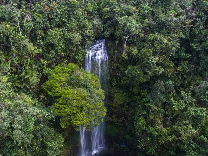
The department of Putumayo belongs to the Amazon region, located in southwestern Colombia, on the border with Ecuador and Peru. With an area of more than 24,000 km², Putumayo is a territory of extraordinary diversity: from the Andean peaks of Alto Putumayo, with its páramo landscapes and inter-Andean valleys, to the lowland jungles of Bajo Putumayo that merge with the great Amazon. Its capital, Mocoa, is a city nestled between mountains and jungle, sadly known for the 2017 mudslide tragedy, but also for its resilience and its environmental value as a corridor between the Andes and the Amazon. The 13 municipalities of Putumayo offer a cultural, natural and ethnic wealth that makes it one of the most fascinating departments of Colombia.
LIST OF MUNICIPALITIES OF PUTUMAYO IN ALPHABETICAL ORDER
Below is the list of the 13 municipalities of Putumayo in alphabetical order:
- Colón
- La Hormiga (Valle del Guamuez)
- Mocoa
- Orito
- Puerto Asís
- Puerto Caicedo
- Puerto Guzmán
- Puerto Leguízamo
- San Francisco
- San Miguel
- Santiago
- Sibundoy
- Villagarzón
Below are the 13 municipalities of Putumayo listed organized by subregion:
| Municipality Name | Subregion |
| Colón | Alto Putumayo |
| San Francisco | Alto Putumayo |
| Santiago | Alto Putumayo |
| Sibundoy | Alto Putumayo |
| Mocoa | Medio Putumayo |
| Puerto Caicedo | Medio Putumayo |
| Puerto Guzmán | Medio Putumayo |
| Villagarzón | Medio Putumayo |
| La Hormiga (Valle del Guamuez) | Bajo Putumayo |
| Orito | Bajo Putumayo |
| Puerto Asís | Bajo Putumayo |
| Puerto Leguízamo | Bajo Putumayo |
| San Miguel | Bajo Putumayo |
MUNICIPALITIES OF PUTUMAYO BY POPULATION
Below are the 13 municipalities of Putumayo ordered from largest to smallest population:
| Name | Inhabitants |
| Puerto Asís | 67.201 |
| Mocoa | 42.156 |
| Orito | 40.832 |
| La Hormiga (Valle del Guamuez) | 37.914 |
| Villagarzón | 28.347 |
| Puerto Leguízamo | 21.543 |
| San Miguel | 20.812 |
| Puerto Caicedo | 17.234 |
| Puerto Guzmán | 16.891 |
| Sibundoy | 15.047 |
| San Francisco | 8.321 |
| Santiago | 7.654 |
| Colón | 6.432 |
MUNICIPALITIES OF PUTUMAYO BY CLIMATE
Putumayo has one of the widest climate variations in Colombia. The Sibundoy Valley, in Alto Putumayo, has a cold mountain climate with temperatures around 13°C, while the municipalities of Bajo Putumayo such as Puerto Asís reach 27°C in a humid Amazonian warm climate. This climatic diversity over such a short distance is one of the most striking features of the department. Below is the list of the 13 municipalities of Putumayo ordered from warmest to coolest climate:
| Municipality Name | Average Temperature |
| Puerto Leguízamo | 27º c |
| Puerto Asís | 27º c |
| San Miguel | 26º c |
| La Hormiga (Valle del Guamuez) | 26º c |
| Orito | 25º c |
| Puerto Caicedo | 25º c |
| Puerto Guzmán | 24º c |
| Villagarzón | 24º c |
| Mocoa | 22º c |
| San Francisco | 18º c |
| Santiago | 16º c |
| Colón | 14º c |
| Sibundoy | 13º c |
DATE OF FOUNDATION OF MUNICIPALITIES OF PUTUMAYO
The municipality of Sibundoy is one of the oldest in the department, with missionary presence since the 17th century. The Sibundoy Valley was an important center of evangelization for the Inga and Kamëntsá indigenous peoples. The municipalities of Bajo Putumayo are more recent, linked to the rubber boom and later oil exploitation. Complete list of the 13 municipalities of Putumayo with their respective foundation dates:
| Municipality Name | Date of Foundation |
| Colón | 1967 |
| La Hormiga (Valle del Guamuez) | 1978 |
| Mocoa | October 12, 1563 |
| Orito | 1963 |
| Puerto Asís | 1912 |
| Puerto Caicedo | 1972 |
| Puerto Guzmán | 1968 |
| Puerto Leguízamo | 1919 |
| San Francisco | 1967 |
| San Miguel | 1978 |
| Santiago | 1967 |
| Sibundoy | 1608 |
| Villagarzón | 1968 |
MUNICIPALITIES OF PUTUMAYO NEAR MOCOA
Mocoa, the department's capital, is a strategic point between the Andean foothills and the Amazon rainforest. Via the Troncal del Magdalena highway and the road to Bajo Putumayo, the capital connects with the municipalities of the middle and upper subregion of the department. The municipalities closest to Mocoa are those of Medio Putumayo and the Sibundoy Valley.
- Villagarzón
- Puerto Caicedo
- San Francisco
- Sibundoy
- Colón
- Santiago
- Puerto Guzmán