Municipalities of Guaviare
Complete list of the 4 municipalities of Guaviare in alphabetical order, by population, climate and founding date. All the information of each municipality.
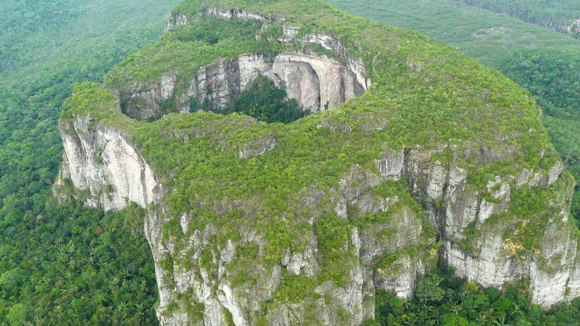
The department of Guaviare belongs to the Amazon region of Colombia and is located in the transition between the Orinoquía and the Amazon, forming one of the most spectacular natural landscapes in the country. With 53,460 km² in area, the department is home to rock formations over 1 billion years old such as Cerro Azul and the tepuis of Chiribiquete, declared a UNESCO World Heritage site. The Guaviare River, one of the great tributaries of the Orinoco, is the main communication route and gives the department its name. Indigenous Nukak-Makú communities, considered the last nomadic people of Colombia, coexist in its territory alongside settlers who arrived especially from the 1970s onwards. Guaviare was established as a department in 1991, separating from Meta, and San José del Guaviare is its capital and main urban center.
LIST OF MUNICIPALITIES OF GUAVIARE IN ALPHABETICAL ORDER
Below is the list of the 4 municipalities of Guaviare in alphabetical order:
- Calamar
- El Retorno
- Miraflores
- San José del Guaviare
Below is the 4 municipalities of Guaviare in a list that includes the area to which it belongs:
| Municipality Name | Area |
| San José del Guaviare | Center-North |
| El Retorno | Center |
| Calamar | Center-South |
| Miraflores | South |
MUNICIPALITIES OF GUAVIARE BY POPULATION
| Name | Inhabitants |
| San José del Guaviare | 75000 |
| El Retorno | 23000 |
| Calamar | 12000 |
| Miraflores | 9000 |
MUNICIPALITIES OF GUAVIARE BY CLIMATE
| Municipality Name | Average Temperature |
| San José del Guaviare | 27º c |
| El Retorno | 27º c |
| Calamar | 26º c |
| Miraflores | 26º c |
DATE OF FOUNDATION OF MUNICIPALITIES OF GUAVIARE
The municipalities of Guaviare are relatively young in their formal recognition, as the colonization of this territory was late and gradual. San José del Guaviare was founded in 1938 as a small settlement of settlers and Capuchin missionaries, and grew rapidly from the 1960s onwards with the opening of new roads and colonization processes. The other municipalities of the department are even more recent, some elevated to municipal status only with the 1991 Constitution that created the department. Complete list:
| Municipality Name | Date of Foundation |
| San José del Guaviare | 1938 |
| El Retorno | 1965 |
| Calamar | 1968 |
| Miraflores | 1970 |
MUNICIPALITIES OF THE DEPARTMENT OF GUAVIARE
The 4 municipalities of Guaviare are connected mainly by river and air, although San José del Guaviare has a road that connects it to Villavicencio and Bogotá. Access to Miraflores and Calamar is mostly by small plane or by the Vaupés River and its tributaries. Most of the departmental territory is covered by Amazon rainforest and transition savannas, with enormous expanses without permanent inhabitants. The Serranía de Chiribiquete National Natural Park, the largest protected area in Colombia with more than 4 million hectares, covers a large part of the Guaviare territory and is famous for its rock paintings over 20,000 years old. The local economy is based on cattle ranching, subsistence agriculture, fishing and emerging ecotourism linked to Chiribiquete.