Orinoquía Region of Colombia
Orinoquía: list of 4 departments (Arauca, Casanare, Meta, Vichada), capitals, climate and profiles. Amazon transition overlaps where they apply.
Updated 23 Sep 2026 · Source: Wikipedia / geography
The Orinoquía region of Colombia (also called the Eastern Plains) is one of the country’s six natural regions. It groups 4 departments: Arauca, Casanare, Meta and Vichada.
The Orinoquía stretches east of the Eastern Cordillera: savannas, wetlands, large rivers of the Orinoco basin and llanero culture. Meta and Vichada can show a transition toward Amazon ecosystems; in this list they remain primarily Orinoquía.
See the natural regions hub.
Departments and capitals
| Department | Capital | Profile |
|---|---|---|
| Arauca | Arauca | /en/departamento/arauca/ |
| Casanare | Yopal | /en/departamento/casanare/ |
| Meta | Villavicencio | /en/departamento/meta/ |
| Vichada | Puerto Carreño | /en/departamento/vichada/ |
Also touches
| Territory | Note |
|---|---|
| Meta (Sierra de la Macarena and foothills) | There is a transition toward Amazon ecosystems; the department stays in the Orinoquía. |
| Vichada | A soft transition toward the Amazon region; main listing = Orinoquía. |
| Foothills in Boyacá, Cundinamarca and others | A relief note; it does not change the cards for this region. |
Meta and Vichada are not listed as primary departments of the Amazon region.
Location and relief
East of the Colombian Andes. Plains and savannas predominate; toward the Andean foothills the relief rises. La Macarena is an isolated mountain landscape inside Meta. To the south and southeast there is a gradual transition toward Amazon forest.
Climate
Mostly warm, with a rainy season and a drier season that sets the cycle of the savannas and cattle ranching. We do not cite °C or mm without a source.
Hydrography
The region belongs to the Orinoco basin. Reference rivers: Meta, Guaviare (limit / transition), Arauca, Casanare, Vichada, and the Orinoco along the border.
Economy
- Extensive savanna cattle ranching
- Oil and gas in municipalities of Arauca, Casanare and Meta
- Agribusiness (rice, palm, cereals on the foothills and high plains)
- Trade in Villavicencio and the other capitals
- Nature tourism and llanero culture
Culture, food and festivals
Llanero culture: joropo, harp, cuatro, maracas; coleo and cattle work.
Food (examples): carne a la llanera (mamona), hayacas, river fish, cheese and dairy.
Festivals (selection): International Joropo Tournament (Villavicencio); Song and Joropo Festival (Arauca and other municipalities); patron-saint festivities and cattle fairs in Yopal, Puerto Carreño and llanero towns.
Natural parks (selection)
- El Tuparro National Park
- Sierra de la Macarena National Park
- Tinigua National Park
- Cordillera de los Picachos National Park (foothills / contact)
Llanero landscape
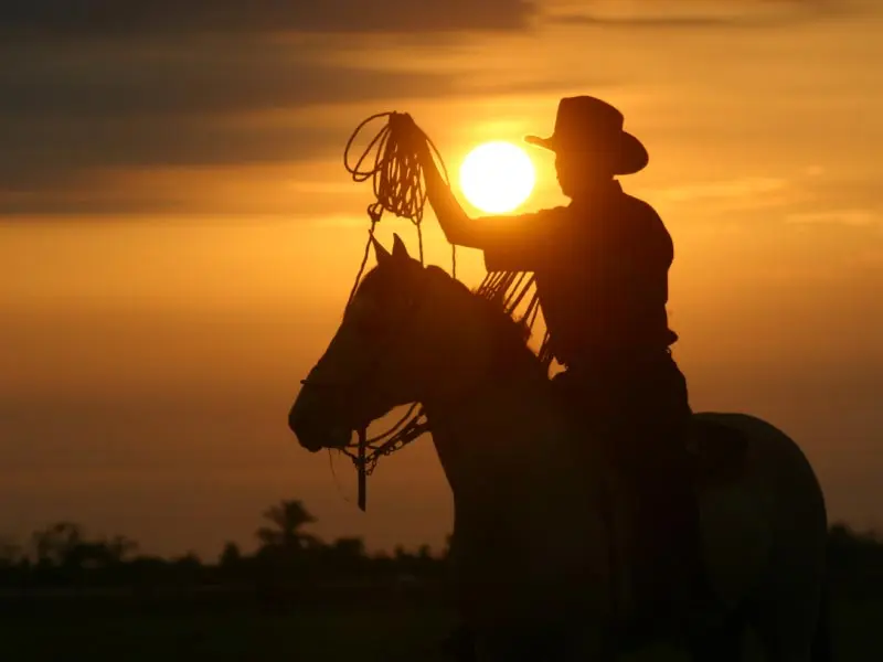
The classic image of the Orinoquía is open savanna, cattle, joropo and rivers that leave the Eastern Cordillera for the Orinoco. On the foothills (Meta, Casanare, Arauca) there is more humidity and crops; toward Vichada, high plains and a lower population density predominate.
Villavicencio is the gateway to the Llanos from Bogotá. Puerto Carreño, Arauca and Yopal organize trade, services and energy in their departments. Nature tourism (Tuparro, Caño Cristales in regulated visiting seasons, wetlands) depends on access and the season.
Relation to the Amazon
The line between the Orinoquía and the Amazon is not a political wall. Savanna grades into forest. That is why some lists mix Meta or Vichada with the Amazon. The reading here is clear: Meta and Vichada = Orinoquía (4); Amazonas, Caquetá, Guainía, Guaviare, Putumayo and Vaupés = Amazon (6), with a soft transition note where it applies.
Hydrography and daily life
On the Llanos the river sets routes, seasonal floods and ranch boundaries. In the rainy season many wetlands expand; in the dry season animals concentrate and savanna tracks open. That is why cattle ranching and transport follow the climate calendar.
Arauca and Casanare combine border, energy and llanero culture. Meta concentrates population and services. Vichada adds huge areas and a lower density. Together they are the 4 departments of this region.
Gateway to the Llanos
Villavicencio connects Bogotá with the Orinoquía. From there routes open toward the Ariari, the high plains and, with lower density, toward Vichada. Arauca and Yopal concentrate services and energy. Puerto Carreño looks to the Orinoco and the border.
Naming the 4 departments (Arauca, Casanare, Meta, Vichada) corrects presentations that only said “four” without a list. The transition toward the Amazon is explained in notes, without moving Meta or Vichada into the table of 6 Amazon departments.
Frequently asked questions
How many departments does the Orinoquía have?
4: Arauca, Casanare, Meta and Vichada.
Are Meta and Vichada Amazonian?
As primary listings, no: they belong to the Orinoquía. There can be an ecological transition (for example La Macarena), but they are not added to the 6 of the Amazon region.
Is the Orinoquía one of the classic geographic zones?
Yes. It appears in five-continental-zone frames and also as one of the six natural regions in this guide.
Other regions
Sources
Copy review: 23 Sep 2026 (America/Bogota). Version v3-mau-wikipedia.